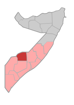
Bakool
Bakool
Bokool | |
|---|---|
 Location in Somalia. | |
| Coordinates: 4°20′47″N 43°32′59″E / 4.34639°N 43.54972°E | |
| Country | |
| Regional State | |
| Capital | Huddur |
| Area | |
• Total | 26,962 km2 (10,410 sq mi) |
| Population (2019[1]) | |
• Total | 1,156,400 |
| • Density | 43/km2 (110/sq mi) |
| 1,234,456 | |
| Time zone | UTC+3 (EAT) |
| Area code | Bakool |
| HDI (2021) | 0.295[2] low · 14th of 18 |
Bakool (Somali: Bakool, Maay: Bokool, Arabic: بكول) is a region (gobol) in southwestern Somalia.[3]
Overview
[edit]It is bordered by the Somali regions of Hiiraan, Bay and Gedo.
Bakool, like Gedo, Bay and most parts of the Jubbada Dhexe (Middle Juba) region, used to be a part of the old Upper Region, which was subdivided in the mid-1980s. The town of Hudur is the administrative capital of the region.
In March 2014, Somali Armed Forces assisted by an Ethiopian battalion with AMISOM re-captured the Bakool province's capital Hudur from the Al-Shabaab militant group.[4] The offensive was part of an intensified military operation by the allied forces to remove the insurgent group from the remaining areas in southern Somalia under its control.[5]
Districts
[edit]The Bakool region consists of five districts:[6][a]
Major towns
[edit]- El Barde
- Aato
- Hudur
- Qurajome
- Rab Dhuure
- Tiyeglow
- Wajid
- Yeed
- Yowkooyow
- Buur Dhuhnle
- Garasweyne
- Moorigaabey
Notes
[edit]- ^ Some sources list Rabdhure, others Yed
References
[edit]- ^ "Somalia: Subdivision and cities". www.citypopulation.de. Retrieved 2024-02-14.
- ^ "Sub-national HDI - Area Database - Global Data Lab". hdi.globaldatalab.org. Retrieved 2018-09-13.
- ^ "Somalia". The World Factbook. Langley, Virginia: Central Intelligence Agency. Retrieved 6 December 2013.
- ^ "Somalia: Federal Govt, Ethiopian forces liberate strategic town of Hudur". Garowe Online. 7 March 2014. Archived from the original on 8 March 2014. Retrieved 8 March 2014.
- ^ "Somalia: Federal Govt, AMISOM troops clash with Al Shabaab". Garowe Online. 11 March 2014. Archived from the original on 11 March 2014. Retrieved 11 March 2014.
- ^ "Regions, districts, and their populations: Somalia 2005 (Draft)" (PDF). Archived from the original (PDF) on 2017-07-28.
External links
[edit]


